 |
Stage 2022/04 [SA004] | ||
|
Purmamarca - Cuesta de Lipan (RN52) |
|||
| 14 mi / 22 km | |||
| 1210 Hm (garmin edge 1000) max. Altitude: 3620m | |||
Cuesta de Lipán by bicycle: cycling from Purmamarca to Argentinas Salinas Grandes. |
|
Today the adventure starts. Today it will be mountainous. We leave Purmamarca on Ruta 56 heading northwest, towards the Puna. The term Puna means “high land” in Quechua and describes the northwestern part of Argentina on the Altiplano. The Altiplano and the Puna lie between the eastern Andes (Cordillera Oriental) and western Andes (Cordillera Occidental) at an average altitude of 3600m. And cycling from Purmamarca to the Altiplano between the east and west Andes, you first have to cross the East Andes. That's how it is. We plan to enter the Altiplano crossing the Cuesta de Lipan at an altitude of 4170m. Today's starting point, Purmamarca, is at 2400m, giving us any reason to get up early. |
|
In the first section, Ruta 56 follows the valley of the Rio de la Quebrada de Purmamarca, a river that in August is better described as a dry riverbed. With every kilometer we cycle westbound, the Andes around us rise higher and higher. The road is in very good condition: The road was laid out as a gravel road in the early 1970s and was upgraded to an asphalt road in 2000. The name Ruta 56 also comes from this time. |
|
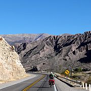
The landscape is at least as spectacular as the rocks formations around Purmamarca: color and shape of the mountains change every few kilometers. As a cyclist you feel quite small surrounded by the huge mountains rising on both sides of the street. |
|
Over the first 8 kilometers the gradient is very pleasant at less than 5% and we steadily gain altitude. The slight climb helps to warm up since it is quite cool here in the morning. The Andes impress with their intense yellow . . . |
|
|
 With every Kilometer we cycle westbound, the valley becomes more and more narrow and the road becomes steeper. On average the gradient is now 4% to 7% and the air becomes noticeably thinner. 12 kilometers 7 miles west of Purmamarca the road becomes a mountain road and runs along a steep slope. |
 After 14 kilometers / 9 miles we cross the 3000 meter altitude mark. On this section of the road the first hairpin curve is waiting for us. Our bicycles are loaded with food and water for several days, which doesn't make the climb any easier. |
 Our goal for today is to reach the section behind the six narrow hairpin bends between kilometers 19 and 21 / between mile 12 and 13. The straight section behind these six bends is located at an altitude above 3500m, bringing us in a good position to cross the Lipan pass at 4170m / 13680ft tomorrow. |
 When cycling along the straight section behind and above the six hairpin curves we decide to spend the night here at an altitude of 3620m. It is not easy to find a suitable campsite in the steep terrain. When planning the tour, we identified the area west of this curce as a possible campsite. On site, however, the inner area of the hairpin curve seems to be even more suitable: an earthen wall offers protection from cars and views, the area is flat and has an acceptable flat surface. There are even bushes for some more privacy. So we set up our tent and start to prepare hot tea. The idyllic photos don't mention the fact that it's very cold and windy up here. In the early evening the sun disappears behind the western mountain range and it instantly becomes cold. By cold I mean: really cold! If you spend the night here, you should bring suitable equipment with you! |


