 |
Stage 2022/03 [SA003] | ||
|
Lozano - Tumbaya - Purmamarca (RN9) |
|||
| 47 km / 29 mi | |||
| 1000 Hm (garmin edge 1000) | |||
Cycling the north of Argentina to Purmamarca. |
 North of Lozano, the Ruta Nacional 9 becomes spectacular. Traffic is light, the asphalt is good. This time of the year, end of August, 26°C / 79°F it is pleasantly warm here. The road follows the Rio Grande de Jujuy, which is a bit confusing because a few kilometers further downstream the river is suddenly called Rio San Francisco. |
 Shortly before a village named Volcan, the R9 follows a series of serpentines with 200m / 650ft elevation gain up to an altitude of 2146m / 7040ft, before descending again twards the river bank after a short descent north of the Rio Del Medio. The short climb with a gradient of over 6% could have been avoided following the old road, but given the excellent condition of the road, we gratefully accept the offer of a short mountain training session. Today we classify every effort as altitude training category: 200 meters in altitude going up and down again is good for acclimatization. |
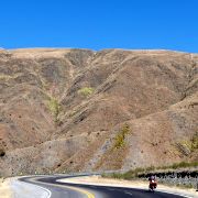
 We take a quick breather and then head back down into the valley of the Rio Grande de Jujuy. The mountains to the left and right of the valley have no vegetation and the further north we go, the more impressive and colorful the rocky mountains become. |
 We are now in the Quebrada de Humahuaca, a gorge that reaches to the town of the same name, Humahuaca. North of Volcan the first red colored rocks appear. The different rock layers have different colors, which makes the mountains appear amazing colorful. |
 In addition to the changing colors, the mountains always surprise with changing rock formations. First the landscape consists of soft hills and a short distance later the environment changes to rugged rock faces covered with cacti. The cacti are Leucostele atacamensis: as the name suggests, this species only occurs in higher mountain elevations between 2000m and 4000m or 6500ft to 13000ft. |
 In Tumbaya it is time for a break and we decide to have lunch at a small place on the main road. Given the high temperatures, we are choose a place in the shade. On the menue there are empanadas, fried eggs and bread. |
 As we continue to cycle along the R9 northbound, we continue to enjoy the red rock formations for which this region is known. The red tone stands out particularly against the gray, sometimes greenish-looking rock. The landscape becomes a bit surreal. |
 In the early afternoon we leave the Ruta Nacional 9: while the R9 continues to the north through the Quebrada de Humahuaca towards Bolivia, we turn left following the R52 westbound in the direction of Susques. Like Ruta 9 the Ruta 52 is also paved and in very good condition. |
 A few kilometers down the road we reach our destination for today: Purmamarca at an altitude of around 2300m / 7450ft. The name on the town sign can hardly be recognized anymore due to a terrible bad habit of todays culture: why on earth do people need to stick their supposedly individual stickers everywhere? My generation was teached to leave nothing but footprints and to take nothing but photos. Yeah, I know, culture changes. We stay in Purmamarca for two nights. On the one hand, to get used to the altitude, and on the other hand, to have enough time to explore the rock formations that Purmamarca is known for. |
 Purmamarca is known for the Cerro de los Siete Colores, the mountain of seven colors. The different colors are caused by different minerals in the rock and are very impressive. The photos don't come close colors they have and do no justice to the impression these mountains give. It is much more than you can imagine when looking at the pictures, so recommend you go there and see them by yourself. |
 It's best to explore the terrain on foot, because the mountains look completely different every few meters. The position of the sun also influences the perception of colors, so we are there all day to have a look at the area at different times of the day. |
 Purmamarca has a long tradition as a place to find shelter for the night, as the Incas used Purmamarca as a rest area. Purmamarca is located on the Inca Trail Qhapaq Ñan, an Onca road that connected what was then Quito (in today's Ecuador) with Santiago de Chile. The city of Cusco and the famous Machu Picchu were also on this ancient road. At that time, the Inca road allowed the transport of goods, troops and messages, the latter also by express messenger (Chaski), if things were urgent. For the Incas, Purmamarca was probably some kind of an Amazon warehouse. |
 Considering the stages ahead of us, we do like the Incas did and use Purmamarca to eat extensively, replenish our supplies and eat extensively again. And to drink: there a many wineries in the northwest of Argentina. Grapes that are fine with the low temperatures at night find good conditions here: there is more than enough sunshine for them. |


